Roman Building Projects
A Marker of Social Organization and Military Success
Republic
Road Building
- The Roman road was at the very heart of the Roman system of cities, villas and agriculture
- Ancient Roman perception of territory and space was much more fluid than the modern view;
Example - Provincia did not refer to a specific geographic region but to the exercise of imperium by a military command
- The people within the provinciae were classified as Roman citizens, allies (civitates foederatae), free cities or free peoples (civitates liberae)
- Roman road building was complicated by class conflict
- The elite looked to Rome as a natural leader
- Plebeian class
- Agitated for the abolition of debt bondage
- Regulation of public lands (ager publicus), land usually taken from conquered people and allocated either to Roman citizens, Roman allies, or reallocated to conquered people
- Reforms of the 4th century BC (the beginning of monumental road building), involved the non-elite in the political process
- They fought in Rome’s wars of expansion (both Roman citizens and Roman allies)
- The rewards were booty and land
Via Appia
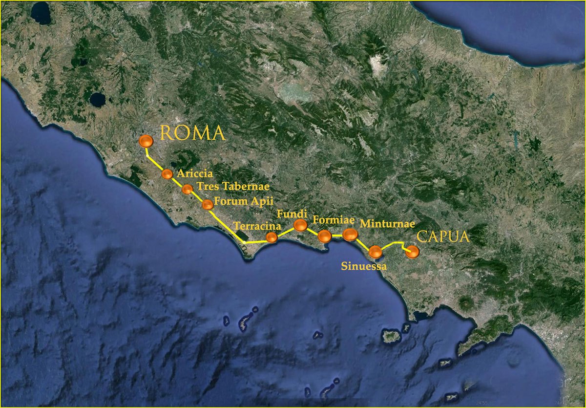
- The first major road, the Via Appia, went from Rome to Capua and was a major financial and physical undertaking
- It linked Rome with Capua, the two most prominent cities on the Italian peninsula
- The road was not paved; it was topped with gravel, called glarea
- A new silver coin was minted to celebrate the occasion
- The project was overseen by the Censor Appius Claudius Caecus
- He gained many clients as a consequence of his allocation of contracts for the building and maintenance of the road
- The road was 8 feet wide, room enough for two wagons to pass each other
- The road was completed in 5 years 312-308 BC
Colonies and way stations were built along the way. The road gave the Romans a strategic advantage over the Samnites by enabling the Romans to get supplies and reinforcements to Campania quickly without interference or complications.
This map was designed by JS Konrad, relying upon Google Earth and various texts. It may be copied and used for educational purposes only. It must be accompanied by the following language and link:”Developed by JS Konrad for Pro Romanis, a GENCYA Communications company. www.proromanis.com.”
- Appius Claudius gained a vast number of clients; from those involved in the building of the road
- In 295 BC, the Via Appia surface was paved in square blocks from the Porta Capena to the Temple of Mars (Liv.9.43.25)
- The next section to be improved, from Temple of Mars to Bovillae (10 miles from Rome) was paved with silex (a form of hard stone, limestone or basalt, Liv.10.47)
- Funding for the two paving projects came from fines levied on pastoralists who exceeded the restrictions of the Lex Licinia of 367 BC
- In 295 BC, the Curule aediles paved the Via Appia from the Porta Capena to the Temple of Mars (which is outside the city walls); simultaneously they had a quadriga drawing Jupiter placed on the roof of the Temple of Jupiter Optimus Maximus and added statues of the twins Romulus and Remus to that of the she wolf; taken together, these all tell the story of the city as successful in warfare
- At Terracina and Minturnae and in Rome, some of the booty captured from the Samnites in 293 BC was displayed in the temples and other public buildings
- The geometric forms of the colonies and the centuriated landscapes would have created an image of territorial control [Laurence (1999).19 of 221.]
- Humm (1996) has argued that the construction of Forum Appii (43 miles/69 kilometers southeast of Rome, the end of the first day’s Journey), the Via Appia and the Aqua Appia, built on the geometric principles of Pythagoras, is what a Greek monarch or Greek tyrant would have done [Laurence (1999).20 of 221.]; this effort by Rome is thought by some scholars to be an attempt to speak to the Greek-speaking cities of southern Italy in a language they understood
Political and military implications
- The Via Appia, built from Rome to Capua, 115 miles away, was a demonstration of Roman power
- Capua was a close ally of Rome
- The Via Appia avoided the Latin cities and towns, passing instead through the Pontine marshes to the sea at Terracina and from there down the coast to Campania, then turning inland to Capua
- It was a strategic response to the disruption caused by Rome’s Latin allies during the first Samnite war, when they rebelled and prevented the Romans from moving supplies to the forward areas in order to combat the enemy; as a consequence, the Romans could not achieve their wartime aims and had to sue for peace
- The road was promoted and its construction overseen by Appius Claudius Caecus, Censor, a champion of plebeian rights
- The project faced opposition from the Consuls
- Two military colonies were planted along the Via Appia; 1) Minturnae; 2) Sinuessa

